Hiking Alamere Falls – Bolinas, California
I finally made it out to one of my Bay Area bucket list destinations – Alamere Falls. Alamere is a rare California tidefall, a waterfall that streams directly onto the beach. It’s one of only two in northern California!

Alamere Falls Hike, Bolinas, California // tahoefabulous.com
We approached Alamere Falls from the south on the Coastal Trail outside of Bolinas, California. The trail is about 8 miles round trip, and fairly flat and easy, aside from the unmaintained trail to the top of the falls and the sketchy climb to the beach below the falls.

Trail Map via Strava
I had never been to Alamere, and Greyson hadn’t been in years, so we were surprised by the amount of people who were doing the fairly long hike on a Sunday. We had to park about a half mile away from the trailhead due to the amount of cars in the parking lot and along the road. We also were stopped several times before we made it onto the trail by people asking if “this is the trail to the waterfall?”
I’m not sure if it is always that busy on weekends or if it was exacerbated by some outside cause, like the gorgeous weather or being featured in a magazine or newspaper article. We saw several hundred people over the course of the ~3.5 hours we spent on the trail and on the beach. If you’re looking for a relaxing, people-free adventure, this may not be the hike for you, or be sure to time it on a week day during an off time.
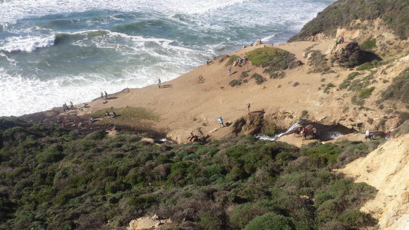
Crowds at the top of Alamere Falls
Despite the many people (many who lacked basic hiking etiquette – we saw tons of dogs in the dog-free wilderness area, people hiking while blasting music, and other rude trail behavior), the Alamere Falls hike was totally worth it for us. The tide was way in, so there wasn’t much beach and we were dodging the waves, but the view of the waterfall falling into the waves was incredible!

Because there were so many people and loose dogs running around, the steep and loose climb down to the beach and back to the trail was extra sketchy. If you’re not sure-footed and used to scrambling, I’d recommend staying on the top of the cliff and enjoying the still amazing view of the falls from above.

Elevation Profile via Strava
Though fairly long, the trail is mostly flat and not technical, so it ends up being a fairly easy hike to the top of the falls and back. There are great ocean views on some sections of the trail, and once the haze cleared out, we could see back to the skyline of San Francisco. It should definitely be on your Bay Area Bucket List!

Can you spot the SF skyline?