Five Awesome Fall Mountain Bike Rides in Tahoe-Truckee

Tahoe Truckee Fall Mountain Bike Rides // tahoefabulous.com
Fall, or “Locals Summer”, is hands down my favorite time to go mountain biking in Tahoe and Truckee. The weather is cooler, the trails are less crowded, and, if we’re lucky, we’ve gotten some rain to help tamp down the dust. However, some rides are better than other in the fall. Some trails get over ridden throughout the summer and are too loose by September, and others are high enough that early season snow renders them unrideable. Here are some of my favorite Truckee and Tahoe trails to ride in the fall.

Fall Riding Donner Lake Rim Trail // tahoefabulous.com
Donner Lake Rim Trail, Truckee, California
The Donner Lake Rim Trail, which currently traverses about 10.5 miles of single track above the north side of Donner Lake is an awesome fall ride. Other than some loose, dusty corners, the trail holds up really well into the late fall. The Donner Lake Rim Trail has some of the best views of Donner Lake, it’s one of the best mountain biking trails for fall colors. It’s easy to access, has plenty of parking, and it connects to other local trails, like Hole in the Ground and Wendin Way. The Donner Lake Rim Trail has sections for everyone, from beginners to advanced riders. The Castle Valley segment is rocky and technical, the Drifter Hut Switchbacks are mostly flowy with some tight corners, and the Skislope segment is either a mellow climb up or ride down. For more details about the trails, check out my Trail Guides for the Donner Lake Rim Trail from Castle Valley and from Glacier Way. I haven’t written a trail guide for the newest section of the Donner Lake Rim Trail that connects to Northwoods Drive, but you can check out my video of the trail here.

Fall Riding Corral Trail Network // tahoefabulous.com
Upper Corral and Incense Cedar Trails, South Lake Tahoe, California
While Truckee mainly gets dusty in the fall, South Lake Tahoe trails tend to get sandy from decomposed granite. This route consisting of Upper Corral and Incense Cedar mostly avoids the sandpits that form in the fall. To access the trails, head up Fountain Place Road, a paved road that can be ridden or shuttled. Upper Corral is a pretty technical downhill trail, earning its advanced rating on Trailforks. There are some tricky turns, mandatory drops, and long rock gardens, though all the features are walkable if needed. Incense Cedar, on the other hand, is a mellow trail that’s mainly downhill, with a few short climbs sprinkled throughout. Incense Cedar pops out onto Powerline Road, a fire road that can get pretty sandy in spots, but is rideable back to the parking area on Fountain Place. To see my Strava track for this route, click here. For more information about the Corral Trail Network, click here for my trail guide.

Fall MTB Riding Royal Gorge Rim Trail // tahoefabulous.com
Royal Gorge Rim Trail, Soda Springs, California
The Royal Gorge trails on Donner Summit make for great fall riding. The trails were designed with mountain biking in mind, so they hold up well. Also, since they’re less well known than other Truckee trails, they have much lower traffic than something like Jackass, and aren’t as beat up as a result. For a great fall ride, I’d recommend the Royal Gorge Rim Trail Loop, which is a little over 6 miles and about 1,000 feet of climbing. Be sure to take the Routen Peak Spur, and enjoy the incredible views. Click here to see my video featuring the Royal Gorge Trails.

Fall MTB Rides: Big Chief Trail // tahoefabulous.com
Big Chief Trail, Truckee, California
One of the newest, techiest trails in Truckee is an incredible fall ride, the Big Chief Trail. The trail is mainly in the thick forest, and is well built so the dirt segments hold up well, even after long, dry periods. There are also incredible rock work, long rock gardens, and gravel sections which won’t get very loose and dusty. It’s made up of two sections, Big Chief Upper and Big Chief Lower and can be accessed by a 7.7 mile fire road climb on the 06/Sawtooth Road. It can also be shuttled and some people ride up the trail. The trail is multidirectional, but most riders tend to ride up the fire road. The whole ride is about 15.7 miles and around 2,000 feet of climbing. For my trail guide, click here.This is a trail for advanced and intermediate riders, especially the upper section - there are some big drops, tight corners, and technical rock gardens. I ended up walking quite a few features on Big Chief Upper! For an easier ride, you can easily just do Big Chief Lower, as the start of this segment crosses the 06 at about mile 3.7. If you’re looking for even longer ride, you can tack on Sawtooth Loop or other trails in the Sawtooth network. Click here to see my video of Big Chief Trail.
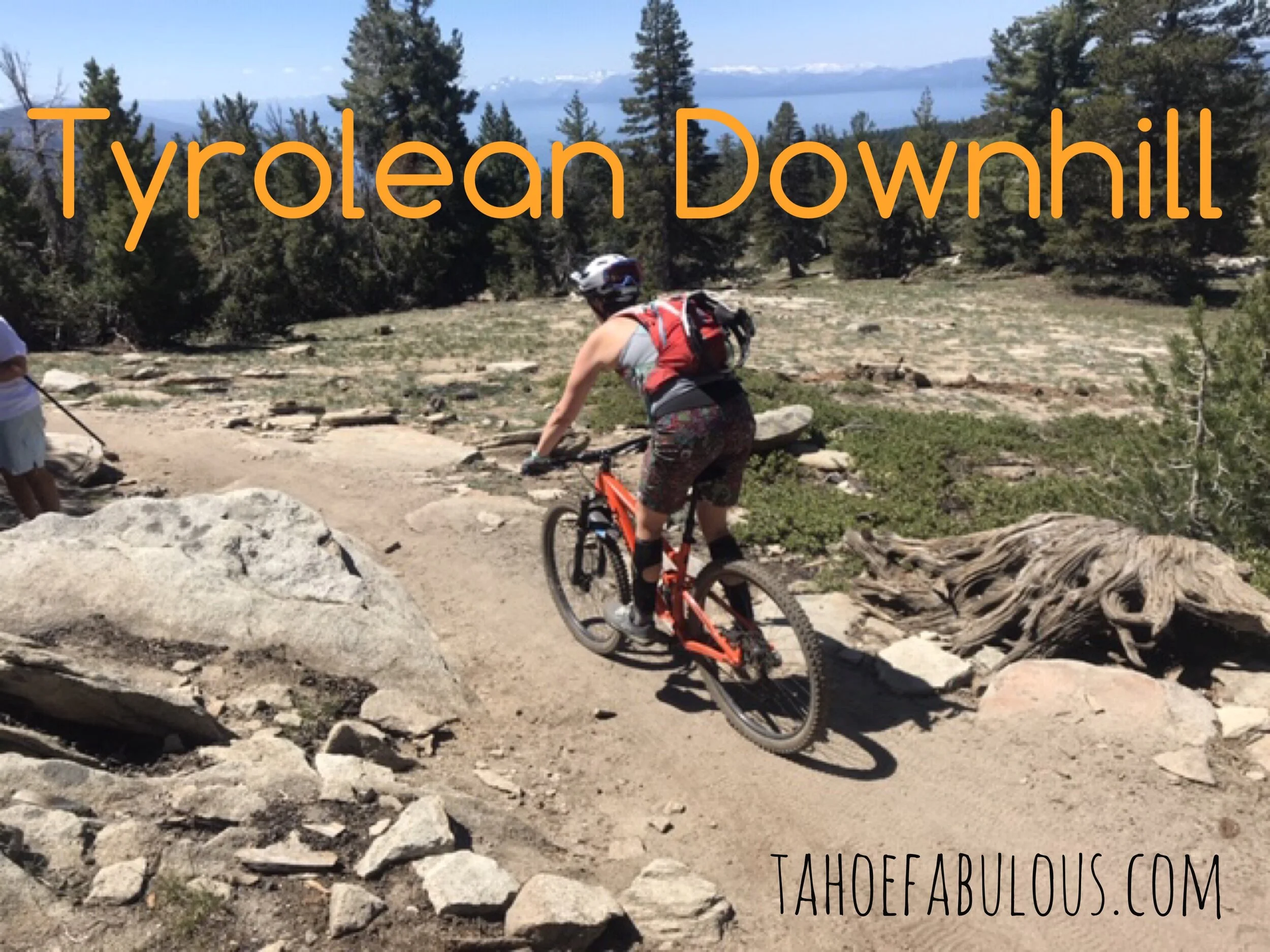
Tyrolean Downhill, Incline Village, Nevada
The Tyrolean Downhill is an awesome shuttle trail that gets sandy, but is still an excellent late season ride. It’s got incredible views of Lake Tahoe and takes you through a variety of classic Tahoe terrain. Tyrolean has features that will challenge advanced riders, but the majority of the technical features have ride arounds that make this doable by intermediate riders - without losing the flow!To do the Tyrolean Downhill as a shuttle (which most riders do), leave one car parked at the Diamond Peak Ski Resort parking lot, where the trail ends. While there are several ways to access the Tyrolean Downhill, my favorite is via the Tahoe Rim Trail (TRT). Park at the Tahoe Meadows Tahoe Rim Trail parking area, off of Highway 431. Hop on the TRT: Tahoe Meadows to Tunnel Creek segment, and after about 1.6 miles, you’ll hit ab intersection. Turn right to get on Upper Tyrolean, which is a mellow flowing ride through the forest. After about 1.15 miles, Upper Tyrolean turns into the Tyrolean DH, which drops nearly 1,650 feet in 3.3 miles! The trail ends at the Diamond Peak parking lot, making this a super easy shuttle, with only about 350 feet of climbing over about 6 miles. Click here to see my Strava route, but ignore the spur at mile 0.8. We were riding through patchy snow at the top and took a wrong turn. For my video of the Tyrolean Downhill (also featuring a trail race and a bunch of runners who aren’t usually there), click here.