Mountain Biking Culvert & Confluence in Auburn, CA
This weekend, Greyson and I checked out a couple of awesome, new to us mountain bike trails in the Auburn, California area. We've spent a fair amount of time on the Foresthill Divide Loop trail, which is a fairly easy cross country oriented trail, but had yet to ride any other trails in the area. Internet research led us to a loop featuring Culvert and Confluence trails, which looked awesome from the videos we'd seen (like this one by BKXC).
There are a few different ways you can ride these trails, including shuttling or starting at the top, but we decided to get the climb out of the way first. To access this trailhead, which is in the Auburn State Recreation Area, a little north east of the city of Auburn, you can put "Lake Clementine Trail Auburn" into Google Maps and follow the directions - here's a link. We were there on a beautiful, sunny Sunday and we ended up having to park fairly far up on Old Foresthill Rd. Parking is $10 in the Auburn SRA, but if you have a California State Parks Pass, that covers your parking.

Clementine Trail // tahoefabulous.com
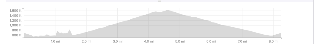
We started by heading up Clementine Trail which is south east of the bathrooms/payment kiosk just across the little bridge. Clementine starts as a wide double track that parallels the American River that narrows down into single track. At about 0.2 miles in, there's a Y in the trail, with the fork to the right heading up steeply. Don't take it, stay left! (Greyson and I did - oops.) During the singletrack section, Clementine is pretty mellow, thought there are a few small rocky sections and optional drops and there's some exposure on the narrow parts. The trail turns back into double track, and you'll get to ride under the famous Foresthill Bridge, the highest bridge in California. After the bridge, the trail starts climbing steadily upward, gaining ~340 feet in about 1.1 miles.

Mountain Biking Auburn // tahoefabulous.com
Clementine Trail peters out on Clementine Road, which we continued climbing for another 540 feet of climbing. After about 1.4 miles on Clementine Road, there's a gated trailhead to the right. Fuel Break Trail heads uphill on the right. Fuel Break is between a fire road and double track, and it's the last bit of climbing on this route. The trail is about 0.7 miles and ~140 feet of climbing. It tops out at a gorgeous meadow, which is a perfect spot to stop for a snack, then heads downhill for about 0.1 mile.

Culvert Trail // tahoefabulous.com
Here we broke off from Fuel Break onto Culvert Trail on the left. Culvert is a fun flow trail, that drops through open oak woodlands. The trail is on the easier side of intermediate, with small berms and optional drops and jumps and a few small rock gardens. You'll ride through a large culvert under Foresthill Road (hence the name), where you should probably take your sunglasses off, if you want to be able to see! Culvert Trail ends at Old Foresthill Rd. after about 1.2 miles at the sign for Mammoth Bar.

Confluence Trail // tahoefabulous.com
Head straight down the paved road, looking right for the Confluence Trail sign, which is at about 0.2 miles after the intersection. The Confluence Trail is definitely the most technical part of this loop but is completely rideable by a confident intermediate rider. There are some rocky sections and narrow parts with significant exposure - but everything is walkable if necessary. Early on, there was a short, slid out section that we needed to get off and walk across. The steep drop off into the American River Canyon is a little nerve wracking, but the incredible river views are the highlight of the route. Confluence is about 1.8 miles and ends back at the trailhead where we started. Including riding from where we were parked and a short, steep detour, this route was about 8.25 miles and 1,300 feet of climbing, which we did in two hours including breaks.


Culvert and Confluence Trails // tahoefabulous.com
I had a great time on the trails in this area, and I can't wait to head back for more exploring. This area is pretty popular, not only with mountain bikers, but also with hikers and dog walkers, so be aware of your surroundings and practice good trail etiquette. One of the best things about riding in the Auburn area are the opportunities for awesome post ride beers. This time, we hit up Knee Deep Brewing Co., but Moonraker Brewing is another favorite.
Trail Stats
Location: American River Confluence, Auburn, CA
Mileage: ~7.25 miles
Elevation: ~1,100 feet
Difficulty: Intermediate
Nisenan Land